Graphics: last 8h (scaling: 5°)


Graphics: last 8h (scaling: 10%)


Graphics: last 8h (scaling: 5°)


10 minutes tendency


| current |
Min.(16:15) |
Max.(07:40) |
average |
| 0 hPa/1h | -1 hPa/2h | -1 hPa/3h | -1 hPa/12h | -1 hPa/24h |
(old formula)
Graphics: last 8h (scaling: 5°)


E-NE
without sensors/ID
68,1 °C |
37,8 °C |
12,74 g/m3 |
1,0715 kg/m³ |
kp/m² |
0,0 (reference Temp. 0 °C) |
0,0 (reference Temp. 20,0 °C) |
0,0 ( - - ) |

|
|
|
|
|
|
Cloud base o. ground
Snowfall liwith m. o. NN
(calculated)

| ||||||||||||||||||||||||||||||||||||||||||||||||||


| last hours | 0,0 mm | |
| today | 0,0 mm | |
| last 24 hours | 0,0 mm | |
| current week | 0,0 mm | |
| current month | 24,9 mm | |
| last month | 70,4 mm | |
| julij Previous year | 146,1 mm | |
| current year | 803,9 mm | |
| rain / year | 64 days | |
| 12-days Grafic (20.07.2026 - 31. 07. 26) |
     |
scale: 0-10 mm scale resolution: 1,0 mm |
| 12-month Grafic (avgust 2025 - julij 2026) |
          |
scale: 0-400 mm scale resolution: 40,0 mm |
| today | 0,0 mm | |
| current month | 183,6 mm | |
| last month (junij) | 160,9 mm | |
| current year | 661,6 mm | |
| 12-month Grafic (avgust 2025 - julij 2026) |
             |
scale: 0-200 mm scale resolution: 20,0 mm |
| 12-month Grafic climatic water balance (268 mm) (avgust 2025 - julij 2026) |
           |
scale: +/-400 mm scale resolution: 80,0 mm |
| Tmin 10,3 °C 31. 07. 15 Tmin ø 15,0 °C 31. 07. 15 WCmin 10,0 °C 31. 07. 15 |
Tmax 33,8 °C 31. 07. 17 Tmax ø 25,2 °C 31. 07. 20 WCmin ø 15,0 °C 31. 07. 15 |
rain max 14,0 mm 31. 07. 15 Gust max 0,0 km/h 31. 07. 08 DPmax 24,0 °C 31. 07. 20 |
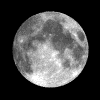
| age of the moon | 16 days, 11 hours, 56 minutes | |
| moonrise | 21:30 | |
| moontransit | 02:11 | |
| moonset | 07:21 | |
| moon phase | ß 97%
(0% = new moon, 100% = full moon) | |
| last quarter | 04:22 06. 08. 26 | |
| first quarter | 04:47 20. 08. 26 | |
| next full moon | 06:19 28. 08. 26 | |
| next new moon | 19:37 12. 08. 26 | |

| sunrise yesterday | 05:41 30. 07. 26 |
| sunrise | 05:42 |
| suntransit | 13:07 |
| sunset | 20:31 |
| daylight | still 7:26 h |
| sunrise tomorrow | 05:43 01. 08. 26 |
| day length | 14:49 h |
| night length | 9:11 h |